Saturday 17 April 2010

Pictures from last run


Finding the Coast Path at Clovelly. It was a sunny Sunday morning so the car parks were full of cars suggesting people were out using the path, but later on the remoter areas between car parks were still empty.


At first much of the path looked like this, skirting around the edge of fields for about 6 miles.


Now and then the path would dip down onto the beaches between cliffs and I'd have to cross the water. This one was particularly fun, jumping from stone to stone.


I saw lots of wild Dartmoor ponies on this section of the track. I took this photo looking back along the coast I'd already covered and liked the way you could see all the way to Saunton in the distance, strange to think that's where I was running just a few weeks ago.


Just before East Titchberry the path was blocked due to a landslide. The notice pinned to the post here had a map of the alternative route to take and the diversion was helpfully signposted all the way to Hartland.


The lighthouse at Hartland Point; a dramatic spectacle in real-life, even if this photo does make it look like a chess piece!


My attempt at showing the time I reached Hartland (which was about a third of the way). Unfortunately the sun's reflection on my phone screen meant I couldn't actually see what I was taking a photo of until I got home, and on this occasion just missed my watch!


Pretty steep round here!


A random ruin on Warren Cliffs, with the village of Hartland in the distance.


The rock formations on the coast between Hartland point and Hartland Quay were extraordinary. I've heard this part is a good place to see seals too, but if there were any they were well hidden when I passed.


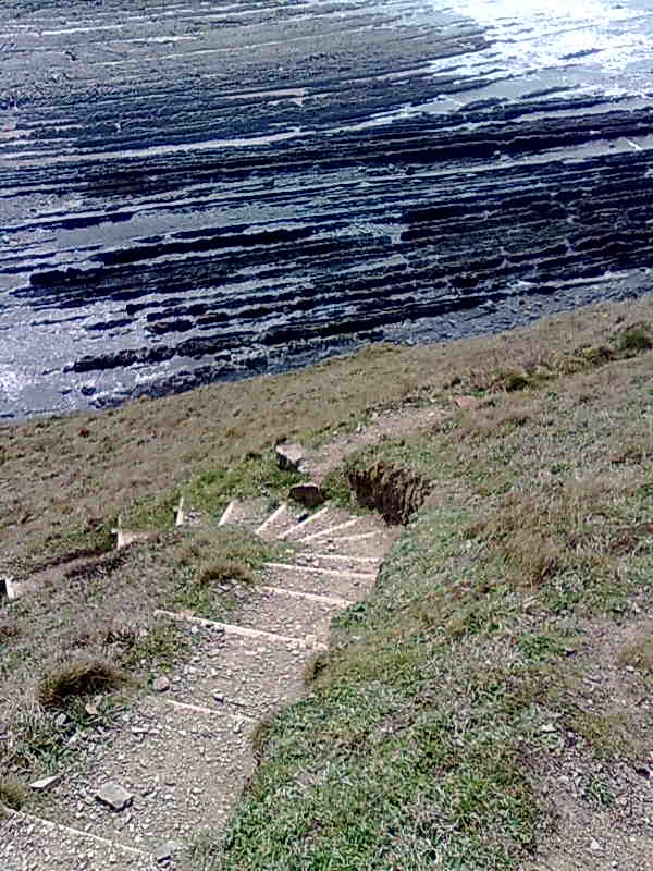
More breathtaking rock formations (and steps that were literally breathtaking too).


Amazing waterfall at Welcombe Mouth.


A highlight of the trip was when I encountered this little hut halfway down a cliff. The sign on the door said 'Ronald Duncan Hut is Open' so I went in and found a table laid out with bottles of water and drinking glasses and a guest book to sign. At this point I had been running for over three hours and this simple shelter looked like heaven! So I treated myself to a moment of rest out of the sun, in front of the delightful view with the lovely cool water to drink and left my heart-felt thanks in the book. (I also left my blog address, so if by any chance the responsible person is reading this, thank you so much, you are wonderful!). I have since found out that Ronald Duncan was an author and poet who built the hut so he could write whilst looking out to sea. I can certainly vouch for it being an inspirational place.


Yes!!!! I was overjoyed to see this sign confirming I'd reached the border.


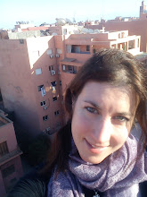
A couple of miles later I stumbled towards my waiting chauffeur and reached the end! Here I am outside the Hawker's Hut on the Coast Path just West of Morwenstow, 20 miles away from where I started in Clovelly, Devon, and over a hundred miles from where I began it all in Somerset.

Coast challenge week 9 (part b)

Well, I've done it! My challenge is over! The last long run took me from the Devonshire village of Clovelly to just over the Cornish border, a total of 20 miles and the end of my Coast Path journey. I feel proud to have got there and have got through so many tough miles, but also sad because it has been tremendous fun and I will really miss having a project to plan my weekends around. Now the experience is over I feel a little lost. During these last weeks I have seen some amazing views and ventured across remote parts of the coastline that I would never otherwise have seen; I have run through snow, hail, wind, rain and sunshine, and learnt that distances on the coast are extremely deceptive- a coastal mile is not nearly the same as a mile on the flat!

As if to remind me what I'd be missing when it was over, this last run was the most spectacular of them all scenery-wise and full of gruelling climbs rewarded by stunning views and flat fields to free-fall across at the top, typical of the highs and lows the Coast Path can throw at you. As it was a beautiful sunny day I saw far more people on the Path than usual, although they were always concentrated in a small radius around the major tourist spots like Hartland Point, with the Path all to myself in the remoter sections (or between National Trust car parks!). For the first time in this whole challenge I had to deviate from the official Coast Path as the Path had been closed following a landslide somewhere between East Titchberry and Hartland but a couple of miles running on the diversion through farms and back roads actually made an enjoyable change and allowed me to do some 'real' running for a bit.

As I got nearer and nearer to Cornwall the sea view seemed to grow more expansive, and the rugged hills to get steeper. The fields and woodland around Buck's Mills and Clovelly seemed like another country, far far away. The last hour (the run took 4:30 in total) seemed interminable and the plunging cliffs never-ending, so I was delighted to see a sign announcing I had arrived in Cornwall, which spurred me on as I knew then my finish line was not far off. A real highlight was just before the sign, when I came across a hillside hut supplied with fresh water for drinking. The sun was high in the sky and I was feeling the effects of too much exposure, so a quick drink in the shade was heaven.

The end of the run was marked with a reviving cream tea in a nearby pub (the Bush Inn at Morwenstow). Whilst replacing vital carbs with scones and jam, my very understanding (and muddy-running-shoes-in-car tolerant!) friend and I sat in the garden whilst I wallowed over the last few months' journey. It felt strange to look at the coast sprawled out on either side and literally see the distance I had travelled. Even stranger to drive back along the Atlantic Highway to Barnstaple later on and pass signs to all the points of interest I'd run past in preceeding weeks, the miles which had taken hours in the other direction simply disappearing under my wheels like sand running through my fingers...

And now it's over, every step of the Coast Path through North Devon has been traversed by my faithful trainers (a great deal of it still clinging to the soles and uppers of the once red and white material), and my marathon training is almost complete. Thank you to everyone who has supported me and donated to my Just Giving page, and to the sundries that have kept me going and made it more enjoyable, most especially PB!

Route:

Clovelly- Mouth Mill Cove- Titchberry- Hartland Point- Hartland Quay- Screda Point/Screda Cove- Speke's Mill- Hole Rock- Mansley Cliff- CORNWALL!- Welcombe Mouth- Morwenstow. 20 miles total distance.

Distance on Coast Path:

104 miles

Map:

Sunday 11 April 2010

Pictures from week 9 (Buck's Mills to Clovelly)


Catching up with the path again in Buck's Mills


Looking out to sea from the center of the village


The path climbing up out of the village


Mostly fields and woodland through to Clovelly

This section showed the contrasting scenery found on the Coast Path- here the sea felt miles away.


Glimpse of Clovelly from Hobby Drive

Coast challenge week 9 (part a)

Another short section of the path completed- after Sunday's problematic run I decided to get the next bit of the Coast Path over and done with in a shorter run, so that it wouldn't be such an issue if each mile took three times as long as it should because of the terrain. Thursday's planned 8 miler thus found me returning to the muddy territories around Buck's Mills and inching a bit further along the coast. I ran to the quaint fishing village/tourist trap Clovelly and back along the good old A39 to my car. It was a pleasant run, but still pretty muddy and I was glad I'd made the decision to do it in a short stretch. Like the last couple of miles before Buck's Mills the path mostly went through woodland and across fields and almost made me forget I was right by the sea, but the now-familiar Coast Path signposts kept reminding me where I was and made the zig-zaggy tracks up and down the wooded combes easy to follow. I can't help thinking wouldn't it be great if life was always directed by little yellow arrows telling you which way to go!

At Clovelly I was slightly disappointed to discover the donkey's had gone to bed for the evening and I couldn't see them trundling up and down what is probably the steepest village main street in the World. People who live there must have very strong thighs... Emerging from the Coast Path meant I snuck in under the radar of the domineering Visitor Center which requires anyone entering Clovelly from the road to pay £5.95 just for the privilege of parking and walking through the hangar-like Center to get down to the village. Unless you have come quite a way along the path there is no other way to get there as it's quite remote and there is only the one road open to the public, so I guess they do quite well out of it.

The amazing news is that I am now less than 20 miles away from Cornwall (hurrah!) so the end of my challenge is well and truly in sight. What this also means is that something went a little bit wrong with my maths when I first calculated the distance I had to run to cross Devon on the Coast Path. Those who know me will agree that maths was never my strong point, but I think on this occasion I am not to blame, that the reason the coastline now seems to have shrunk is because my original figure came from the South West Coast Path website's description of the path and perhaps they had included overlapping trails and all miles of the path through Devon even if they are dead-end tracks to viewpoints or alternative routes. You see occasionally I have been faced with the option of 'cliff route' or 'valley route' for example (always choosing the one nearest the sea), and I have not always gone the extra steps to prescribed viewpoints, so I hope this explains why I appear to be arriving at my destination sooner than expected. Anyway, I am nearly there now and won't let disappearing miles dent my excitement!

Route:

Buck's Cross- Buck's Mills- Hobby Drive- Clovelly- Higher Clovelly- Downland Cross (Milky Way adventure park!)- Buck's Cross

Distance on Coast Path:

84 miles to date

Map:


Sunday 4 April 2010

Pictures from week 8


Setting off westbound on the Coast Path- the coastline in the distance can be seen stretching to Clovelly and around to Hartland, a few more weeks worth of runs will hopefully get me there.


Looking back towards Westward Ho! at start


Abbotsham cliffs, or the path before the traumatic mud situation.


Another reason I spend much of the time not running- bit tricky when the path cut down onto the pebbly beach.


I did enough sliding myself on this route

The mud begins....

Coast challenge update week 8

Arghhh! Worst run so far. In fact, the main problem was that today's effort was less of a run than an adventurous hike due to the ridiculously muddy state of the paths. My training plan (courtesy of Runner's World) dictated a 13 mile run today and last week's mega run left my Coast Path progress at Westward Ho! so I decided to run from there to Buck's Mills (just under 7 miles away) and back again. Unfortunately the path between those two places was so muddy that it was impossible to actually run. Even walking was a challenge, and I spent a good hour trying to work out the best strategy (the wide-legged straddle, trying to avoid the wettest part in the middle of the path, or the plunge, wading straight through with little regard for my shoes and clothing- this tactic became default after I slipped and reflexively grabbed onto a deceptively weak branch, thus ending up with a load of thorns in my hand and up to my knees in mud anyway), before wondering if I should call it a day and turn back. But by that point the thought of retracing my steps through all that mud without achieving much seemed so disheartening I decided to press on and try to cut back to my car along the road after Buck's Mills. After all, I thought, it couldn't be much further....

Another SEVENTY minutes later I made it to Buck's Mills. Yes, it took me two hours and ten minutes to cover a distance of seven miles. During this time I met two seperate groups of people, all of whom were wielding hiking sticks and clinging to the side of the slippery trails like first-time skiers, and who shared with me a sort of wartime camaraderie with resigned smiles and sympathetic comments about the tough times ahead in our respective directions. Along the way I passed through all the major stages of despair; denial ("That sign can't say 2 3/4 miles to Buck's Mills, they're wrong, I'm sure it's just around the next corner"), bargaining ("If the mud clears up after this bit of hill I'll run the rest at fast pace intervals to make up the time"), anger ("If I don't see a patch of dry ground soon I'm going to SCREAM"), and near-insanity ("Maybe I'll just take off my soaking shoes and trousers and run barefoot in my knickers, it'd be so much easier..."). Thankfully though, I eventually made it to the village of Buck's Mills and hit the road. By this time I was too tired and dehydrated to make it a decent run back to Westward Ho! but I did enjoy seeing some new places and the way the sea would occasionally pop into view over the hills ahead. Unfortunately taking the road back did add some extra miles onto the route.

Three and a half hours after leaving I was back at the car, more dirty and exhausted than I've been throughout this challenge, with mud and scratches even on my arms and holes in my hand from the thorns. But now that I'm home (and clean and dry) I have to say that I am slightly relishing the battle-weary exhaustion I have, and am looking forward to a very good night's sleep tonight. 'Til next time....

Route:

Westward Ho!- Kipling Tors- Abbotsham cliffs- Greencliffs- Peppercombe- Worthygate woods- Buck's Mills- Buck's Cross- A39 through Fairy Cross- Abbotsham- Westward Ho! 16 miles in total, 7 on coast path.

Distance on Coast Path:


78 miles to date

Map: